-
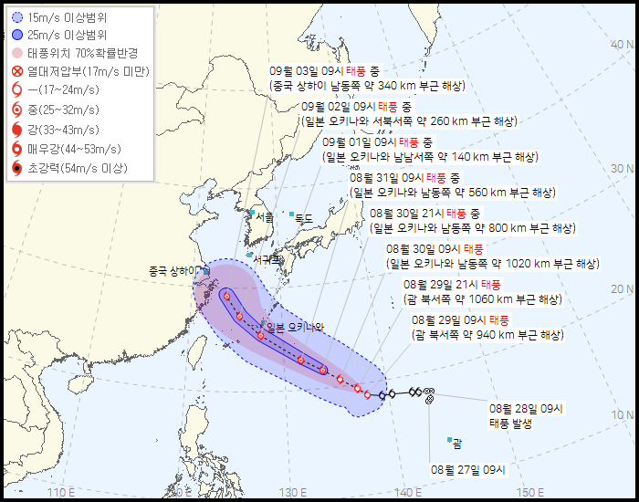
‘불길한 진로’의 태풍 하이쿠이, 카눈처럼 커브 트나지금 이곳에선 2023. 8. 29. 16:10오전 9시 기준 괌 북북서쪽 940km상하이 해상 진출 예보···변동성 커

제9호 태풍 사올라(왼쪽)와 제11호 태풍 하이쿠이(오른쪽)가 9일 낮 12시 기준 열대 해역에서 세력을 유지하고 있다. 기상청 제공
제11호 태풍 하이쿠이가 주말에는 중국 상하이 부근 해상까지 진출할 것으로 보인다. 아직 진로가 불확실한데 한반도에 영향을 미칠 가능성이 있다.
29일 기상청에 따르면 하이쿠이는 이날 오전 9시 기준 괌 북북서쪽 약 940㎞ 해상에서 북북서진하고 있다. 현재까지는 초기 단계다. 기상청은 하이쿠이가 오는 3일 오전 9시쯤에는 중국 상하이 남동쪽 약 340㎞ 부근 해상까지 진출할 것으로 예상했다.
이때의 중심 기압은 975h㎩, 최대 풍속은 시속 115㎞로 봤다. 해수 온도는 높지만 해수 열용량, 대기 상층 발산 등 태풍 발달에 영향을 주는 요소는 충분하지 않아 3일 오전까지는 대형 태풍으로 커지지 않으리라고 보인다.
하이쿠이의 위력, 북태평양 고기압의 경계 위치에 따라 진로는 계속 변한다.
기상예측 모델에 따라 하이쿠이가 중국으로 향할 가능성, 서해안을 지날 가능성, 대한해협을 지날 가능성이 모두 거론된다. 기상청 관계자는 “다음 달 1일쯤에는 한국에 영향을 미칠지에 대한 예측 가능성이 커질 것”이라며 “세력 예보도 변할 가능성이 있다”라고 말했다.
한국에는 31일까지 꽤 많은 비가 내린다. 기상청은 29일 수시브리핑에서 “29일 밤까지 수도권과 강원 영서, 남부에 30일 밤까지는 남부, 제주에 많은 비가 내리겠다”라고 예보했다.
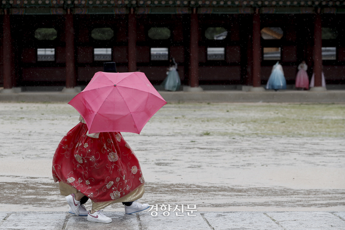
절기상 ‘처서’인 지난 23일 서울 종로구 경복궁에서 한복을 입은 관광객들이 우산을 쓴 채 산책하고 있다. 문재원 기자
29일 찬 공기와 따뜻한 공기의 경계는 한반도 북쪽에 있었지만, 점차 찬 공기가 내려오고 한랭전선이 남동진하며 비를 뿌리겠다. 수도권, 강원 영서는 29일 밤까지 시간당 30㎜ 안팎의 비가 내릴 수 있다. 남부지방에는 남쪽에서 불어오는 바람이 강해지며 해안, 산지 등을 중심으로 지형성 강수가 내리겠다.
30일에는 남서에서 북동으로 폭이 좁은 강수대가 중부지방 이남까지 천천히 내려오겠다. 30일 밤까지는 남해안, 지리산 등 지형의 영향을 많이 받는 지역을 중심으로 시간당 30~60㎜의 매우 강한 비도 내리겠다. 오는 31일에는 남부지방을 중심으로 많은 비가 내릴 것으로 보인다. 북쪽 찬 공기가 내려오고, 동남쪽에서는 북태평양고기압이 확장하면서 생기는 강수대가 오래 머물면 ‘집중 호우’ 가능성도 있겠다.
29~31일 지역별 예상 강수량은 부산·울산·경남 남해안에서 최대 200㎜ 이상으로 가장 많겠다. 경남권에는 80~150㎜, 경북권에는 50~120㎜ 비가 예보됐다. 광주·전남권에도 50~120㎜(전남 동부 150㎜ 이상), 전북 30~100㎜(전북 동부 120㎜ 이상) 등 비가 오겠다.
중부 대부분 지역에는 29일 밤까지 강수가 집중되겠다. 충북에는 29일 오후~30일 새벽, 전라권 대부분에는 30일 새벽까지 특히 강하게 비가 오겠다. 전남 동부·경남권·경북권에는 30일 새벽~밤사이 시간당 최대 60㎜의 강한 비가 내리겠다.
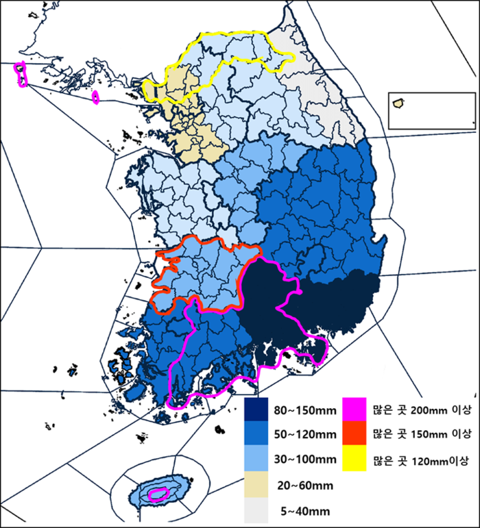
29~31일 강수 전망. 기상청 제공
하이쿠이
제11호 태풍 하이쿠이의 다음 달 3일까지 진로 예보. 기상청 제공
https://www.khan.co.kr/environment/climate/article/202308291226001
'지금 이곳에선' 카테고리의 다른 글
신원식 등 예비역 장성들 "육사 내 홍범도 흉상 반드시 제거해야" (1) 2023.08.29 신원식, 흉상 철거에 "문재인, 국군 뿌리 흔든 건 당신" (0) 2023.08.29 이준석, 홍범도 장군 흉상 이전에 “일부 뉴라이트 사관···백지화하자” (0) 2023.08.29 ‘소련 공산당’ 홍범도·‘남로당’ 박정희…윤 정부 이중잣대 (0) 2023.08.29 철 지난 ‘반공’ 선동하는 윤 대통령, ‘역사 뒤집기’ 노골화 (0) 2023.08.29